BaseLoc DLS Website - Geographical Western Canada
Posted: Tue Aug 28, 2012 8:18 pm
Some of you have undoubtedly used this website before, but I just thought I should post it here since it's pretty handy.
http://www.baseloc.com/dls
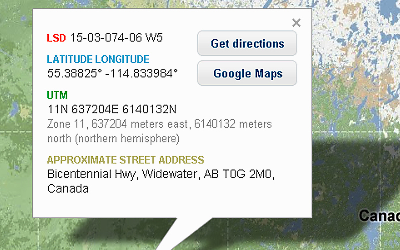
Basically, it's a pretty simple "location converter" website for some of the most common systems of geographical measurement used in Western Canada. Essentially, you can punch in a set of coordinates in any of the three major systems (LDS, UTM, or Lat&Long) or by common street address, and get conversions to any of the other systems OR find the location using google maps technology.

For a basic background on the different systems:
Lat&Long: This is the simple latitude and longitude system used around the globe by many people, which is usually the default setting on a lot of GPS devices.
LDS: This is the "Legal SubDivision" system used mostly in Alberta and also in a few other parts of Saskatchewan. It provides coordinates in the general format of something like 15-03-074-06 W5. Basically, this is part of the Alberta Township System which uses township lines and range lines to divide up the province.
UTM: Universal Transverse Mercator. This system is sort of like the Lat&Long system. The Earth is divided up into grids and placement on the grids is assigned numerical values. UTM is independent of height above the earth's surface. It doesn't really apply near the poles (it runs from 80 degrees South to 84 degrees North). This system was developed by the US Army Corps for military purposes. It doesn't give exact locations with complete accuracy, but it is good for "quick and almost accurate" mapping that the military used several decades ago, before the advent of GPS devices.
The systems are all pretty complicated, but if you are given a set of coordinates in any system, this website lets you converts to other systems quite easily and quickly, and see everything on the map.
http://www.baseloc.com/dls
Basically, it's a pretty simple "location converter" website for some of the most common systems of geographical measurement used in Western Canada. Essentially, you can punch in a set of coordinates in any of the three major systems (LDS, UTM, or Lat&Long) or by common street address, and get conversions to any of the other systems OR find the location using google maps technology.
For a basic background on the different systems:
Lat&Long: This is the simple latitude and longitude system used around the globe by many people, which is usually the default setting on a lot of GPS devices.
LDS: This is the "Legal SubDivision" system used mostly in Alberta and also in a few other parts of Saskatchewan. It provides coordinates in the general format of something like 15-03-074-06 W5. Basically, this is part of the Alberta Township System which uses township lines and range lines to divide up the province.
UTM: Universal Transverse Mercator. This system is sort of like the Lat&Long system. The Earth is divided up into grids and placement on the grids is assigned numerical values. UTM is independent of height above the earth's surface. It doesn't really apply near the poles (it runs from 80 degrees South to 84 degrees North). This system was developed by the US Army Corps for military purposes. It doesn't give exact locations with complete accuracy, but it is good for "quick and almost accurate" mapping that the military used several decades ago, before the advent of GPS devices.
The systems are all pretty complicated, but if you are given a set of coordinates in any system, this website lets you converts to other systems quite easily and quickly, and see everything on the map.